Green space, grey areas: mapping Exeter’s ecological baseline
Exeter is growing fast. Its population reached around 138,000 by mid-2024, up 17% since 2011, and major housing developments are already underway: the Monkerton and Hill Barton urban extension to the northeast, ongoing expansion at Cranbrook, and the Liveable Exeter programme identifying sites for 12,000 new homes within the city. That level of growth puts real pressure on green infrastructure, and raises a straightforward question: what does Exeter’s ecological baseline actually look like, and where are the gaps?
This analysis examines Exeter’s green infrastructure across two complementary lenses: publicly accessible green space, and priority habitats of conservation importance. Together they reveal something that a single dataset cannot: the difference between where people can go and where nature actually thrives.
Public green space: a 12-fold variation across wards
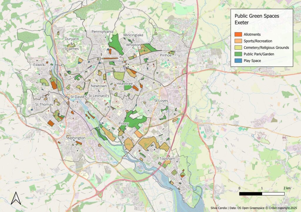
Using OS Open Greenspace, which maps parks, playing fields, allotments, play spaces, cemeteries, and other publicly accessible outdoor land, Exeter has 246 publicly accessible green spaces covering 399 hectares, around 8.5% of the city’s total area.
But the ward-level picture tells a more uneven story. Priory ward leads with 26.4% of its area as public green space, anchored by Ludwell Valley Park and King George V Playing Fields. At the other end, Pennsylvania ward has just 2.2% public green space. That is a 12-fold variation across a single city.
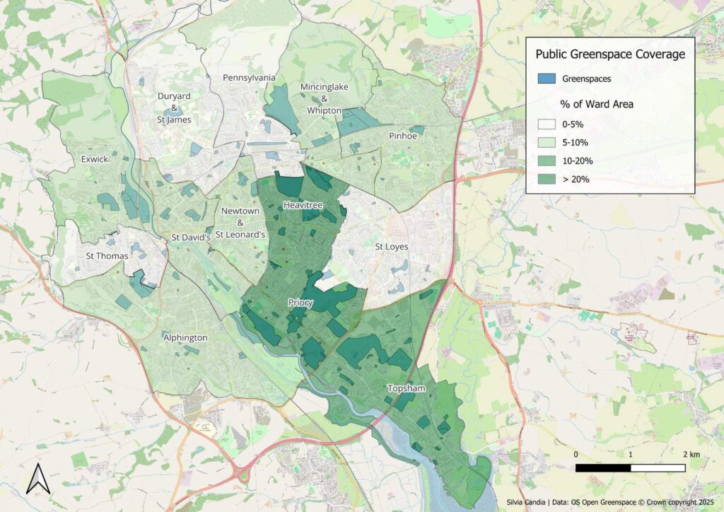
The number of sites alone does not predict coverage. Topsham has the most individual green spaces (40) but ranks third by area, because most are small play spaces and sports facilities. St Loyes has 20 sites covering just 9.5 hectares, a ward of small, fragmented spaces rather than substantial parks.
It is also worth noting what OS Open Greenspace does not capture: private gardens, farmland, unmanaged woodland, and roadside verges. This dataset answers the question “where can the public go?” rather than “where is vegetation?” The two are not the same.
Priority habitats: ecological value does not follow public access
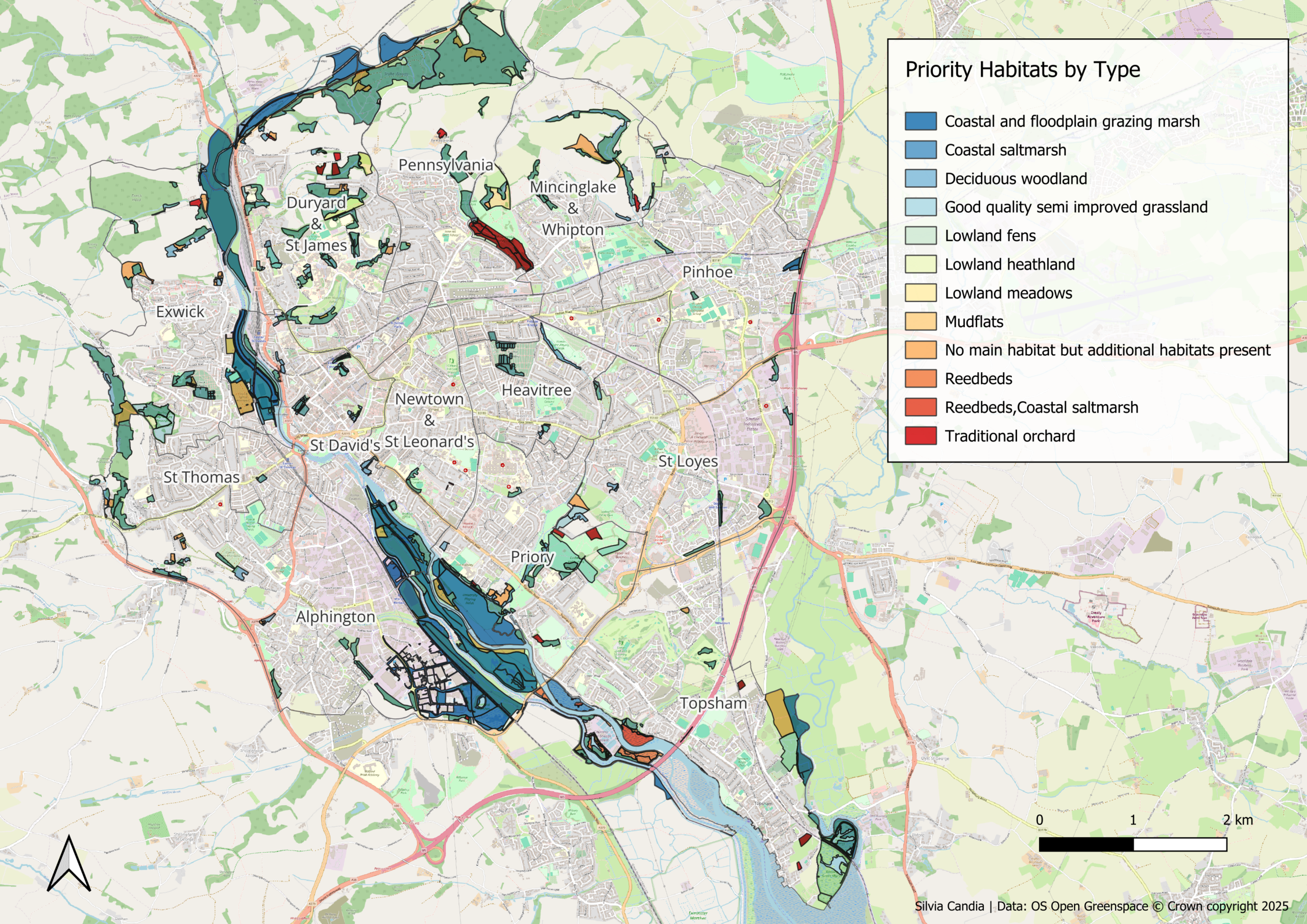
The Priority Habitats Inventory (PHI), published by Natural England, maps habitats defined as most threatened and most important for conservation under Section 41 of the Natural Environment and Rural Communities Act 2006. Across Exeter’s 4,704 hectares, it identifies 599 hectares of priority habitat, 12.7% of the city.
Deciduous woodland is the dominant type at 257 hectares, concentrated along the river valleys and the city’s western fringe. Coastal and floodplain grazing marsh follows the Exe estuary through Alphington and into Topsham. Smaller but ecologically significant habitats include lowland fens and reedbeds at Topsham, traditional orchards scattered across several wards, and coastal saltmarsh along the estuary edge.

The ward-level distribution cuts against the greenspace picture. Pennsylvania leads with 24.4% priority habitat coverage, yet has just 2.2% public green space. Topsham ranks only seventh by habitat area but has the greatest habitat diversity: 10 distinct types reflecting its position at the Exe estuary where freshwater, coastal, and terrestrial habitats meet. Newtown and St Leonard’s, which sits towards the lower end for public greenspace, has just 0.7% priority habitat coverage.
Most priority habitat sits on private land
Overlaying the two datasets reveals a governance challenge. Of Exeter’s 599 hectares of priority habitat, only 101 hectares (16.9%) fall within publicly accessible green space. The remaining 498 hectares (83.1%) are on private or restricted land.
That distinction matters practically. Habitat within public green space can be managed directly by the local authority or its partners, such as Devon Wildlife Trust in the Valley Parks. Habitat on private land depends on different mechanisms: planning conditions, biodiversity net gain requirements, Tree Preservation Orders, and agri-environment schemes. Deciduous woodland illustrates the point starkly: 257 hectares of it exists in Exeter, but only 25 hectares sits within public green space. The remaining 232 hectares falls under statutory protections but is not under direct public management.
What comes next
This analysis covers the first two layers of a four-part ecological baseline for Exeter. The next part will examine total vegetation cover using Sentinel-2 satellite imagery, capturing green cover across both public and private land including private gardens, street trees, and unmanaged verges. A further analysis of habitat connectivity will then map where ecological networks are intact, where they are fragmented, and where targeted interventions could strengthen them.
The data and methods used throughout are open and replicable. All spatial analysis was carried out using Python, GeoPandas, and QGIS, with OS Open Greenspace and Natural England’s Priority Habitats Inventory as primary sources.
If you are working on a Local Nature Recovery Strategy, a BNG assessment, or a green infrastructure plan and would like spatial analysis support, get in touch.